CCC Variation 48
Christchurch City Council's Variation 48 - Management of the Flood Hazards in Christchurch, became operative on 31 January 2011.
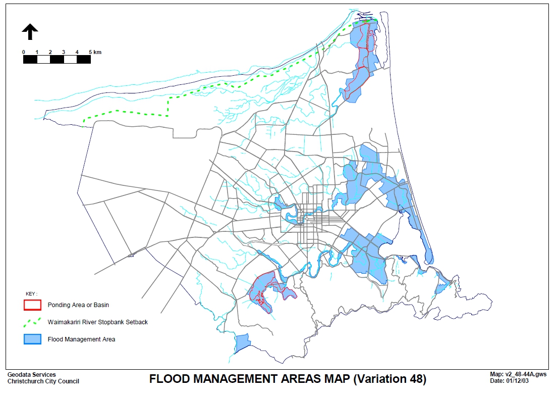
Variation 48 identifies areas of the city subject to a greater risk of flooding as Flood Management Areas (FMAs) and imposes controls on filling and floor levels for development within those areas. Generally, all new buildings, building additions and earthworks within FMAs will require resource consent.
For further information on Variation 48, Flood Management Areas and the potential impact on your project, see the summary below or contact one of ViaStrada's planners now.
- Jeremy 03 943 0830
- Kathryn 03 343 8220
- Andrew 03 943 0833
Variation 48 (Management of the Flood Hazard in Christchurch)
The Christchurch City Council's Variation 48 (Management of the Flood Hazard in Christchurch) to the City Plan became operative on the 31st of January 2011. These provisions apply to all current consents (those building and resource consents lodged with Council but not yet issued as at the 31st of January) and all future consents.
The following is a basic outline of the key provisions as they apply principally to buildings and filling and excavation for building platforms. Please note that the following summary does focus on building construction, however, we are happy to provide further advice specifically on filling and excavation works on enquiry.
-------------------------------------------------------------------------------------------------------------------------
Flood Management Areas
Flood Management Areas (FMAs) are the most widespread areas identified, and include parts of: Lower Styx/Kainga/Brooklands/Spencerville, Burwood (adj. Horseshoe Lake, Avon River, Travis Country area, etc), Wainoni, Bexley, New Brighton, Fendalton, Central City (adjoining the Avon), Avonside, Dallington, South Brighton, Hoon Hay and Beckenham (adjoining the Heathcote), Opawa, Woolston, Linwood, McCormacks Bay, Redcliffs, Sumner, Ferrymead, Heathcote Valley, Early Valley and immediately adjoining Ponding areas - Hendersons Basin, etc
New Plan provisions require resource consent for the erection of any buildings, or additions in FMAs
The following exemptions apply:
(a) Garages of no more than 40 m2 in area and any other accessory building that is of no more than 25m2 in area
(b) Any additions to existing buildings that do not increase the area of the building footprint
(c) Any additions to existing buildings of a maximum of 25 m2 in any five year period
(d) Unenclosed buildings and swimming pools (i.e. car ports).
Additional exemptions relating to rural zones, flood protection works and other filling-related activities also apply.
How this works in practice:
The key consideration with resource consents made under these rules is the finished floor level (FFLs) and site levels relative to the CCC datum. Whilst some variability will exist from site to site and project to project, the indicative levels likely to be required are:
1. A minimum FFL equivalent to an 11.8m level (CCC datum) plus provision of a 300-400 mm freeboard (buffer) for sites subject to 'tidal' flooding
2. A minimum FFL clear of flooding from a 0.5% annual exceedance probability rainfall event, plus an allowance for freeboard (buffer).
CCC staff are able to provide further information on recommended floor levels by:
- Phone/email request
- PIM application
- Resource Consent application
To avoid the need for design amendments and resubmission, early contact with Council to confirm appropriate levels is advisable.
As resource consent is automatically required for building works in FMAs, a Section 37 notice will be placed on Building Consents.
Information requirements for Resource Consent
For resource consent applications (and PIM and building consent applications) the Council will require finished floor levels (FFLs) and site levels relative to the CCC datum to be specified on plans for applications in the Flood Management Areas.
Our understanding is that the Council will be vigorous in their application of the recommended levels (noted above) and if an applicant wishes to argue for a different (lower) level, then the onus is on the applicant to get comprehensive technical advice to justify this.
Conversely, if applications adopt the recommended levels, the consent application should be relatively straightforward and the streamline consent process is likely to be a suitable option.
Key issues to consider
1. Whilst the floor level requirements for sites in FMAs are rising, the Plan's height and recession plane rules remain unchanged. At this time, there are no indications from Council exactly how lenient they may be in their consideration of height and recession plane breaches resulting from increased floor level requirements. It is likely that some breaches will still require notification or affected parties consents.
2. Under the RMA, existing use rights apply where a building is replaced, like for like - no resource consent is needed. However, there are no existing use rights under the Building Act. So, regardless of existing use rights under the Resource Management Act, new buildings / additions will be required to increase floor levels to comply with the Building Act requirement for FFLs providing for a 50 year flood event (which is an 11.4m level CCC datum and only 400mm less than the new City Plan levels).
3. Riverside areas badly affected by the September 4 earthquake and aftershocks are to a large extent within FMAs. Accordingly, these new provisions could be significant for quake-related rebuilding.
4. At this stage, the Council cannot advise what, if any, insurance implications will result from not meeting the Council's recommended floor levels. The Council are currently seeking further advice on this matter.
---------------------------------------------------------------------------------------------------------------------------------
Ponding Areas, Cashmere Stream Floodplain & Waimakariri River
New plan provisions require resource consent for filling and excavation works within Ponding Areas (Hendersons Basin, Cashmere-Worsleys, Hoon Hay Valley, Lower Styx) and on the Cashmere Stream floodplain. These provisions will be limited in their applicability.
There are also provisions relating to the Waimakariri River building setback line.