

This is just a selection of some of the many projects that ViaStrada has been involved in over the years - click on the filter icon to refine the search by topic areas.
Projects
Filter
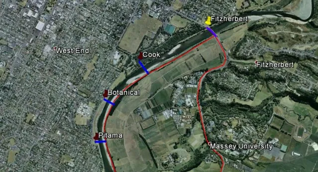
Palmerston North bridge assessment
During 2014, ViaStrada investigated a network of connected shared paths on the southern side (left bank) of the Manawatu River in Palmerston North and
…
Read More
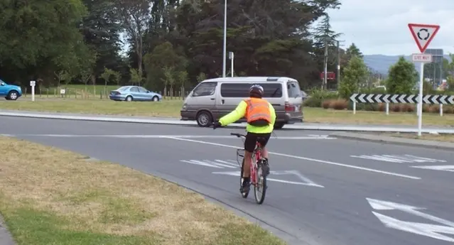
On-road bike lanes at roundabouts research
Do bike lanes make roundabouts safer for cyclists?ViaStrada’s research for Austroads revealed that painted bike lanes at roundabouts may do more harm
…
Read More
South Dunedin cycle network
ViaStrada was engaged to develop the first package of concepts and scheme designs for the South Dunedin Cycle Network, providing cycle facilities with
…
Read More

Dunedin cycleway network development
ViaStrada was commissioned by Dunedin City Council and NZTA to develop a cycling network for South Dunedin and the central city.
Read More

Auckland Cycling Code of Practice
Auckland Transport commissioned ViaStrada to develop the cycling-related content for the region-wide Code of Practice.
Read More
Harbourside arterial active user access
The Otago Regional Council engaged ViaStrada to identify the safety and access issues for walking and cycling along the Harbourside arterial route
…
Read More
Review of cycleway signs and markings
The NZ Transport Agency entrusted ViaStrada with a review of all cycling-related signs and markings in New Zealand to determine whether current
…
Read More

The Brook cycle access
ViaStrada was engaged by Nelson City Council to provide a concept design including cross sections, rough order costs and scheme alignment plans for a
…
Read More

Hastings Walking and Cycling Strategy: beyond iWay
ViaStrada was engaged by Hastings District Council to develop a concise walking and cycling strategy, a list of projects with rough order costs,
…
Read More
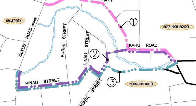
University to City cycle path scoping study
This scoping study for a separated bicycle facility (where cyclists are physically separated from motor vehicles) analysed a variety of routes and
…
Read More
Implementing a central city slow core in Christchurch
Reduced traffic speeds have been shown to improve central city liveability and street activity levels. This 2011 ViaStrada project suggested the
…
Read More
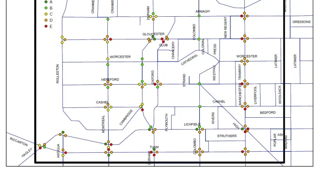
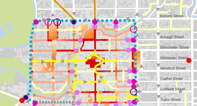
Central city pedestrian Level of Service
Christchurch City Council commissioned an investigation into ways of improving pedestrian level of service (LOS) at traffic signals in the central
…
Read More
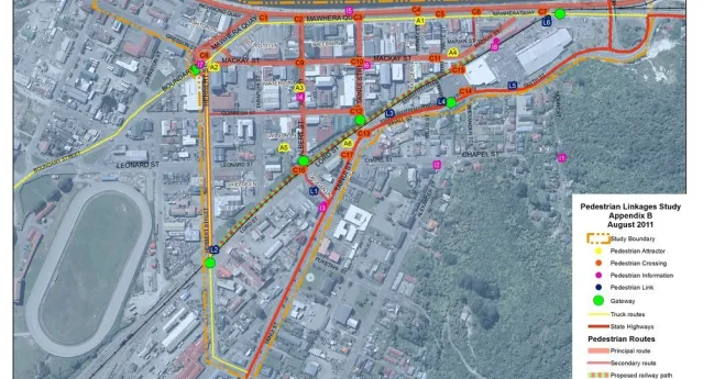
Greymouth pedestrian linkages
This study focused on enhancing the walkability of the Greymouth Town Centre. The comprehensive final report covered high level strategic
…
Read More
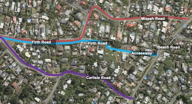
Long Bay network planning
Auckland Transport commissioned ViaStrada to provide cycle network advice supporting the scheme assessment stage of road development in the Long Bay
…
Read More
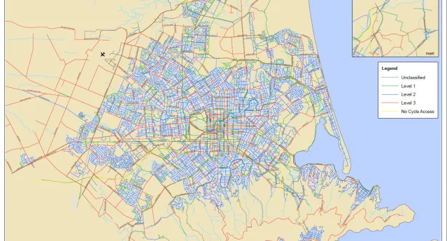
Christchurch cycle network plan
Christchurch City Council (CCC) as part of the Christchurch Transport Plan (CTP) process commissioned ViaStrada to develop a GIS based cycle network.
…
Read More
Hamilton central city 3-level cycling network
The Hamilton City Council commissioned ViaStrada to undertake a review of physical barriers to cycling in the Hamilton central city, as well as
…
Read More

Cycle counting programme: Hamilton
John, Axel and Jeanette have developed an automatic cycle counting programme for Hamilton City Council (HCC). The project identifies approximate site
…
Read More

Christchurch City goes green
The objective of this project was to suggest whether Christchurch City Council (CCC) should continue its use of red coloured surfacing or change to
…
Read More

Green Lights for Bikes
The Melbourne office of SKM engaged ViaStrada to peer review its draft report Green Lights for Bikes, a report on how road authorities can use a range
…
Read More

Further MOTSAM update
NZTA commissioned ViaStrada to update more MOTSAM (Manual of Traffic Signs and Markings) material. Gone are all the old double limit lines, for
…
Read More
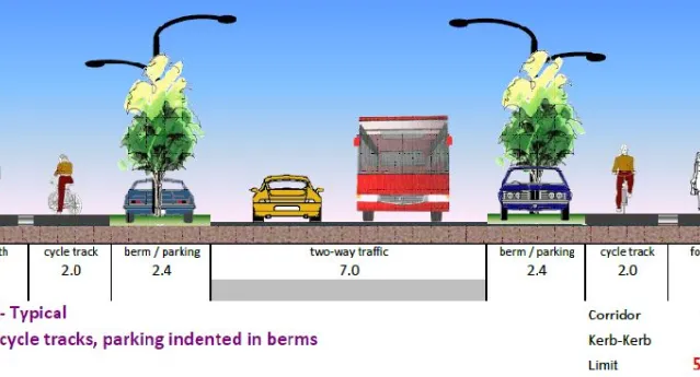
Shared use path width investigations
ViaStrada has undertaken significant research and tool development on behalf of VicRoads (Victoria, Australia) to determine appropriate shared use
…
Read More