Strategies & masterplans

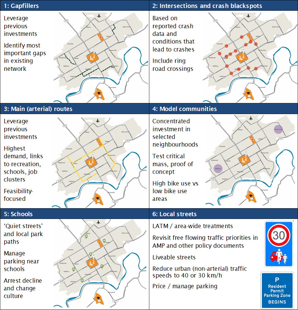
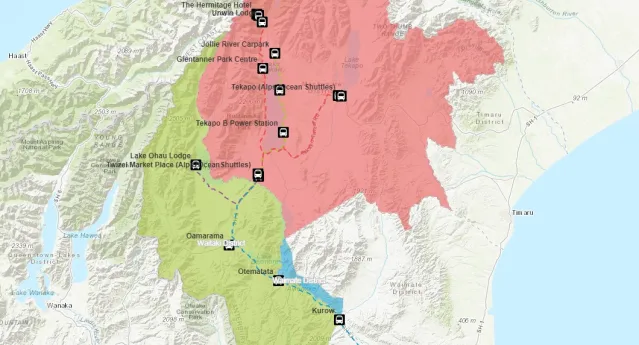
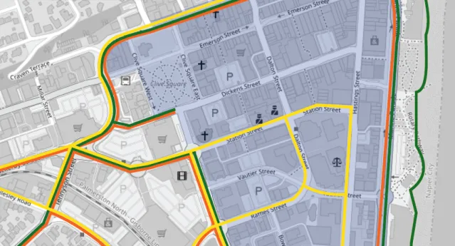
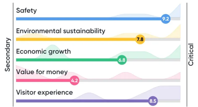
ViaStrada wrote the book on walking and cycling strategies and produced many of the first iterations for councils across New Zealand. Today’s strategies are anchored by buildable concept designs and informed by robust public, iwi and stakeholder engagement. We are specialists in multi-criteria analysis and the only provider of the ActiveTrans Priority Tool (APT). Our prioritisation frameworks are presented in web map form for easy interpretation by clients during development and the public as end readers. Our in-house information designer produces concise and interesting to read documents, and we have experience working with council communications and graphic design staff.

Relevant Projects

  • Tikipunga active travel routes - Single stage business case

    The Tikipunga Single Stage Business Case actions the identified fifth route in the hub and spoke main corridor model within the Whangārei Walking and Cycling Strategy (2018) . The focus of the business case is the city links programme, connecting the Tikipunga town centre to Whangārei City Centre, based primarily upon the residential growth occurring in the area. Following community input, further supporting programme options and recommendations showed a need for local links (between amenities in Tikipunga and Otangarei) and recreational links (for leisure and sports).

    Key Contact: John Lieswyn
  • Dunedin City Cordon Count - 2024

    Dunedin City Council commissioned ViaStrada to run the third (2022), fourth (2023) and fifth (2024) annual iterations of the ‘cordon count’. This count provides a snapshot travel into and out of central Dunedin over time. The term "Cordon” refers to an imaginary boundary around the central city where surveyors were located at the most important entry/exit locations along this boundary. Surveyors were positioned at 30 sites around the central city to count the people and vehicles passing by over two mornings, during the peak from 7:30-9:30 am.

    Key Contact: John Lieswyn
  • Far North Trails Plan - Te Mahere o ta ara tawhiti ki te Raki

    The trails plan actions an identified need in the FNDC Integrated Transport Strategy’s action plan for investment in walking and cycling infrastructure in the district. The plan also responds to the Northland Walking and Cycling Strategy’s regional vision: “For Northland to be one of the world’s best coastal walking and cycling destinations where the journeys and stories are as impressive and memorable as the scenery.”

    Key Contact: John Lieswyn
  • Far North District Council Urban Active Modes Plan

    The Far North District Council commissioned ViaStrada and Abley to develop a geo-spatial approach to determining the annual investment required to improve footpaths in the largest towns. For each town, we prioritised the gaps in the network and estimated the financial investment required to meet a benchmark level of service over various time horizons. We also mapped all streets by ideal pedestrian crossing type to inform future crossing analysis and improvements. 

    Key Contact: John Lieswyn
  • Dunedin parking surveys

    Dunedin City Council staff asked ViaStrada to set up and complete a survey of parking demand in the city centre. The aim of this was to provide a comprehensive picture of parking usage over time (during the day and week) to inform future parking strategies.

    Key Contact: John Lieswyn
  • Dunedin central city cordon count

    How do people arrive in our central cities? Is it changing as we start to invest in walking, cycling and public transport? ViaStrada ran the third annual ‘cordon count’, providing a snapshot of how people arrive at and travel through central Dunedin. 

    Key Contact: John Lieswyn
  • Te Tai Poutini Westland Transport Information

    The Department of Conservation commissioned a report and webmap to summarise the transportation context for the Waiau Weheka Westland long term visitor plan. The work references relevant aspects of over 40 documents and DOC road asset information. The “StoryMap” web-mapping application provides location-specific information on resilience, efficiency, safety and accessibility issues and opportunities.

    ViaStrada adapted to information availability issues and delivered the final product as scheduled and within budget.

    Key Contact: John Lieswyn
  • Whakatāne Wayfinding signage plan

    Whakatāne District Council asked ViaStrada to provide a wayfinding signage plan for Whakatāne District's walking and cycling network. Its focus: how can we help people (and visitors) navigate their community?

    Key Contact: John Lieswyn
  • Active Whakatāne Strategy

    ViaStrada worked with the Client and key stakeholders to update the ten-year old active transport and recreation strategy. Preliminary tasks included an extensive network audit using ArcGIS Data Collector and the preparation of an online StoryMap for planning and public information, online surveys, and in-person public engagement at a range of events. ViaStrada prepared large posters with the findings for public meetings and collated "share an idea" cards. The draft strategy was a concise and graphics-rich document that was lauded by staff and councillors.

    Key Contact: John Lieswyn
  • Mackenzie District Transport Mapping

    The Department of Conservation (DOC) commissioned ViaStrada to create a web map application that summarizes data relating to different topics:

    Key Contact: John Lieswyn